| |
Julius River Forest Reserve, The South
Arthur Forests:
DRIVING
TRIPS AND SHORT WALKS IN THE TARKINE
MURCHISON HWY SOUTH FROM BURNIE
The
Murchison Highway from Somerset (a suburb of Burnie) traverses The
Tarkine on the eastern side. A 30 minute drive will take you to
the Hellyer Gorge. There is a pleasant picnic area and short
rainforest walks each side of the road.
10
kilometres south of the Hellyer Gorge the highway crosses the Wandle river.
There is a very fine walk downstream to Wandle Falls. No more than
600 metres. The walk is on private property and is not signposted.
The track starts right next to the bridge on the southern side.
Another
45 minutes south will take you to Waratah. Mt Bischof is worth a
visit. An old mine a few minutes drive past the hotel overlooking
the waterfall. A good roadhouse, caravan park and a 9 hole golf
course at Waratah.
From
Waratah, there is another hour or so drive to Savage River, an iron ore
mining town. A pipeline runs from Savage River to the coast at
Port Latta near Stanley, straight through pristine rainforest. The
roads are all sealed to here.
Almost
10 kilometres out of Waratah there is a turnoff to the right to
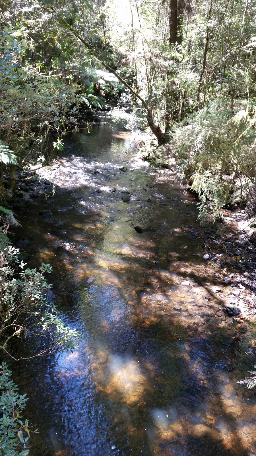
Phoilosopher Falls. A classic Tarkine wilderness rainforest walk.
From
Savage River a narrow road then wanders down to the small hamlet of
Corinna by the tranquil Huon Pine lined Pieman River. The road is
protected by the rainforest canopy and is usually in good condition.
There are short walks each side of the river at Corinna. There is
self contained modern cabin and backpacker style accommodation and a
hotel here. A vehicular ferry operates
across the river ($20 as at Dec 2005) allowing a drive on to Zeehan and Tulla on the Murchison Hwy. A hydro electric dam upstream from
Corinna allows a crossing of the river. A very scenic loop on a
good sealed road. A superb river cruise is available from Corinna
downstream to the Pieman Heads. An overnight stay is necessary to
appreciate the scenic attractions of the heads. Camping only with
no facilities. A superb view to the north towards Sandy Cape from
the hills above the heads. There is a 4WD track from here to
Granville Harbour to the south past Conical Rocks.
From
Corinna an unsealed road continues north to Couta Rocks and Temma.
Before Temma there is a turn right which takes you on to the Arthur
River and the turnoff to the southern end of The South Arthur Forests on a
sealed road.
KIETH
RIVER ROAD
Just
west of Somerset and Wynyard (Burnie Airport) there is a left turn to
Detention Falls. The drive further on takes you through plantation
forest to the Arthur River. Further west are McGowans falls.
The track is not signposted. Directions are
HERE.
There are undocumented walks into the Lyons River area also - Tarkine
Falls and Heaven or
Galadriels Cascades. See
www.thelist.tas.gov.au to search for these areas.
BASS
HWY WEST TO SMITHTON
From
Burnie it is an hour or so drive along the coast to Smithton. Dip
Falls and Stanley are diversions along the way. Smithon is a large
town surrounded by rich farming land. From here, a good sealed
road heads south past Allendale Gardens (a must visit for garden lovers)
to The Milkshake Hills. There is a good camping area at The
Milkshake Hill reserve with clean toilets.
WEST
FROM SMITHTON
The
road west from Smithton takes you to Marrawah - one of Tasmania's
favourite surfing areas. Take the trip down to Ann Bay or further
south to Lighthouse Beach.
A
recently constructed very good road heads south to the town of Arthur
River. A shop with fuel, a caravan park and good camping here.
River cruises are available and are highly recommended. An
unsealed road continues on a few kilometres inland from the coast to
Couta Rocks. The side trips to Sundown Point and in particular Sarah
Anne Rocks are worth the diversion. A very fine 2 kilometre
coastal walk from Sarah Anne Rocks to Couta Rocks.
From
Couta Rocks a road continues a short distance along the coast to Temma.
A very rough 4WD track continues on to Sandy Cape. Trips should
not be taken alone. Vehicles have become stranded in this area and
been completely submerged in quicksand. A special drivers licence is now
required to use this track (as at 2013).
From
Couta Rocks, continue on to The South Arthur Forests and Smithton or south to
Corinna. The Balfour Track runs parallel to the road just before
The South Arthur Forests. Access to the track is now well signposted.
The loop road from Marrawah to Arthur River and on the the South Arthur
Forests and back to Smithton are now sealed. The South Arthur Forest
loop is expected to be sealed by the end of January 2015. We travelled the road
in October 2014 with only 10 kms yet to be sealed.
|
The
Tarkine National Coalition define The Tarkine as summarized below.
The Tarkine in Brief
By Phil Pullinger, Tarkine National
Coalition
Extract from:
http://www.acfonline.org.au/news.asp?news_id=412
Landscapes
The Tarkine contains a wide variety of spectacular landscape features.
These
include;
-
Coastline. Spectacularly wild
coastline, battered by the winds of the
roaring 40s. The purest air in the world. Huge dunes that stretch
inland up to
several kilometres. Rocky, jagged coastal stretches. Incredible
Granite Tor formations
(especially at Conical Rocks south of the Pieman River), extensive
long sandy
beaches, lagoons, grassy woodland, coastal heathland, marshes and
swampland. Sandy
cape forms a dominant and spectacular feature of the Tarkine's
coast.
-
Norfolk Range. Distinctively
rises above coastal plateau, to over 700m.
Contains a belt of sub-alpine rainforest. This region is blanketed
in a tapestry
of heath and buttongrass, moorland, pockets of varying forest types,
and gorge-like
drainage lines.
-
Meredith Range. (reaches over 900
metres) An undulating granite plateau,
the largest exposed area of granite in western Tasmania. Affords
spectacular views
of Cradle Mountain, and the South-West. Pockets and stretches of
tall, implicate
and sub-alpine rainforest exist amongst the granite pillars and
plates of the
Meredith Range.
-
Australia's largest tract of
temperate rainforest. The vastness of
this rainforest is impressive, and reaches/ covers the Arthur,
Pieman, Rapid,
Keith, Donaldson and Savage River valleys. The densely rainforested
upper Savage
River is exceptional due to its deeply incised gorge system.
-
Grand Rivers. The Tarkine
contains two of Tasmania's Grandest Rivers,
the Arthur River (which is the only complete river system in
Tasmania that has
no dam), and the Pieman River. The Arthur River is characterized by
steep gorges
and rapids, valleys blanketed in rainforest, and stretches of giant
eucalypt forest.
It is fed by the Hellyer, Keith, Lyons, Rapid, and Frankland rivers.
The Pieman
River is most famous for its reflections. Like the Gordon, the
Pieman, on a good
day, gives spectacular mirror like river reflections. The section
from Corinna
to the coast is broad and flat and is flanked by rainforests, and
Tasmania's most
northerly stands of Huon Pine. The Whyte, Savage and Donaldson
rivers feed the
Piemans lower stretches. The Upper Pieman river is dammed, and is
fed by the Tarkine's
Huskisson, Wilson and Stanley rivers.
-
Wild Rivers. The Tarkine hosts
Tassie's greatest density of wild rivers
outside the existing WHA. The entire catchments or sub-catchments of
several;
major rivers remain remote and largely inaccessible. These include;
Thornton,
Lagoon, Pedder, Wild Wave, Interview (coastal), Donaldson, Little
Donaldson, Keith,
Lyons, Rapid, and Upper Savage (rainforests), Huskisson and Wilson
(Southern Tarkine).
-
Waterfalls. There are a number of
spectacular known and barely known
waterfalls within the Tarkine's Rainforests. (including
Philosopher's Falls, McGowan's
falls).
-
Cave Systems. The Tarkine
contains globally significant magnesite (dominated
by magnesium) cave (karst) systems. They are potentially the most
significant
if not the only significant system of magnesium cave systems in the
world. They
include caves, sub-surface cavities, sinkholes, springs, and surface
features
including gorges and castle-like formations. They are most
significant in the
upper Lyons river region. There are also a number of small cave
features that
show evidence of Aboriginal occupation within the Savage River
Rainforests.
-
Wilderness. Environment
Australia's National Wilderness Inventory measures
wilderness quality on a scale from 0 (no wilderness) to 20 (pure
wilderness),
based on remoteness from settlement and access, and apparent and
biophysical naturalness.
While the Tarkine contains all gradings, the highest grade, with
values from 14
- 20 makes up the majority of the Tarkine region.
"Sinkhole" by the road - The South
Arthur Forests
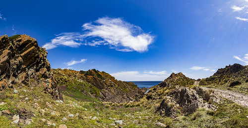
Sarah Anne Rocks
|
|


