INFORMATION INDEX
WHAT TO DO
 TOUR OPERATORS
WHERE TO STAY  
WHERE TO EAT

St Helen's towards the Bay of Fires

Home ] Up ] STANLEY ] ALLENDALE GARDENS ] [ MILKSHAKE HILLS ] MARRAWAH ] ARTHUR RIVER ] SARAH ANNE ROCKS ] HELLYER GORGE ] PIEMAN RIVER ] PHILOSOPHER FALLS ] TARKINE MAP ] TOURING THE TARKINE ] INFO THE TARKINE ]

BALFOUR TRACK
TROWUTTA ARCH
LAKE CHISOLM
JULIUS RIVER
JULIUS RIVER CAVES
BECKETT FALLS
julius cave temp


NOW AVAILABLE

SLIDESHOW DVD's

SELECTED WALKS

BY REGION

The Tarkine

THE MILKSHAKE HILLS - SOUTH ARTHUR FORESTS


A visit to the far North west would not be complete without a trip through the forest reserves in and around the Milkshake Hills.  From Smithton on the far North West there are two main options for continuing further.   The Bass Highway continues on through Dismal Swamp Blackwood reserve to Marrawah and the Mouth of the Arthur River.  The road south heads towards the Arthur River at the Kanunnah Bridge.  20 kilometres from Smithton the road there is a left turn just past Roger River to Trowutta.  The road continues on in a 60 kilometre loop and returns to the main road at Kanunnah Bridge at the Arthur River.  There are some pleasant short walks along the way.


The forestry industry comes under close scrutiny as a result of it's "trash and cash" approach to forestry.  However, The Milkshake Hills is a fine example of the preservation of the natural environment blending in with timber harvesting.


NOTE: The Tayatea Bridge at Celery Top Pine Nature Trail was washed away in the flood of August 2007 making the  loop drive impassable.


The picture above shows the Milkshake Hills from just past the turn off to the forest reserve at the base of the hills.  There is basic camping at the site with a short walk to the top of the hills providing views of the area.
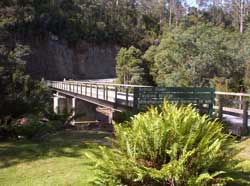
The Tayatea Bridge. Washed away during August 2007.


Part of the camping area.

Part of the view from the hills.